No, I don’t know if their pizza oven will be peat fired. I don’t even know when it will open. All I know is that (hopefully soon) a new pizzeria will open on Islay. In Shore Street in Bowmore to be precise, in the building that most recently housed the Holy Coo restaurant.
With a cold and wet weekend approaching (at least in West Berkshire where I’m writing this) I thought I should pull together something for you to read. Or in other words, write the follow up to the Islay Blogging Roundup NC #1 from almost a month ago. Here are a few Islay and Jura related blog posts I found interesting the last few weeks:
Raptor Politics demands Stop the Scottish Government poisoning eagles through the Geese being shot on Islay, creating a lively debate in his comments. (I don’t know enough about this for any judgement, I’m purely reporting what is written out there)
A little bit of Islay history related to Bowmore distillery can be found in James Mutter’s windows.
I think that’s enough for this roundup, I hope you found something interesting to read this weekend. More to come whenever I’ve collected enough interesting entries, if you have one you think I should mention please get in touch.
The music isn’t from Islay and admittedly the artist doesn’t live on Islay any more, but she was raised on Islay and still returns regularly. That’s plenty enough for me. Oh, and paralegal isn’t a musical term, it’s her ‘day job’ where she recently qualified as paralegal.
The artist in question is Marion Ramsay (Marion Ramsay’s website with a lot of information), she recently set up a Marion Ramsay Contralto Facebook page and hopes you can help with a few ‘likes’ (if you’re on Facebook). To hear her performing you can listen to this sample from her repertoire on her YouTube channel:
A few years ago (well, let’s call it a decade ago) I wrote a post about what I believed to be palm trees on Islay and Jura. Except … they aren’t palm trees. Someone corrected me in the comments, but sadly those comments have since been lost. Recently I came across a post discussing these trees, so I thought it’s worth revisiting the topic so that I have something to refer to when it comes up again.
As mentioned in the previous post the trees in question can be found in a variety of locations on both Islay and Jura, including around Port Ellen, in Bruichladdich and also in the community garden in Bridgend (at least back in 2007, when this picture was taken):
Cordyline Australis in the Islay Community Garden in 2007
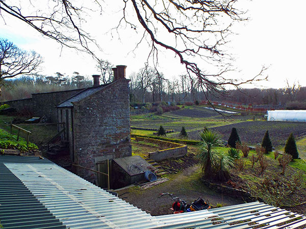
Update:
I must have had a hunch when I wrote this post and mentioned that the picture was from 2007. Sadly the tree has since been damaged in a storm, hopefully it will grow back to its former size. Many thanks to Steve Bavin of Islay Ales for the update!
The same view with a much reduced cabbage tree in Feb 2017 – picture credit Steve Bavin
End of update, original text continues below:
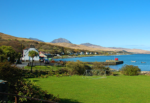
On Jura some of the best known ones can be spotted near the Jura Hotel garden, outside of the Jura distillery:
Cordyline Australis in Craighouse on Jura
So what are these trees really if they are not palm trees? Well, we can read from some people from New Zealand (who should know them, as that’s where these trees are from), when visiting Jura in 2016 they taught the distillery staff about them. The tree is called Cordyline Australis, or cabbage tree. In the UK it is apparently also known as Torbay Palm and Torquay Palm, although that still doesn’t make it a palm tree. Among other things it doesn’t fare well in hot tropical climates, an area where you would expect palm trees to thrive.
So now you know, may be it will be helpful in a pub quiz one day?
Yes, it’s the first of the month. No, it’s not April. It’s February. In other words, this is not an April Fools. Some rather interesting news have come out about Islay and whisky legend (or is it whisky and Islay legend?) Jim McEwan in connection with the currently under construction Ardnahoe distillery overlooking the Sound of Islay. From the press release:
World-renowned whisky distiller Jim McEwan has been appointed Production Director of Ardnahoe Distillery on Islay – 18 months after he retired.
The Islay-born whisky industry icon, who has 53 years’ experience under his belt, has been hired by Hunter Laing & Co, the family-run Glasgow whisky company behind Ardnahoe, the first distillery to be built on Islay for more than a decade.
Ardnahoe is being built on the north-east coast of Islay and will become the ninth distillery on the island. It expects to start distilling whisky in early 2018.
As Production Director at Ardnahoe Distillery, McEwan is playing a pivotal role at the distillery for the Laing family – father Stewart and sons Andrew and Scott. From shaping its design and installing his preferred pieces of distilling equipment, to fine-tuning the production processes and selecting casks, he will influence every step of the whisky-making journey at Ardnahoe.
The distillery, which will include a visitor centre café, shop and tasting room, will produce traditional peated Islay single malt.
McEwan will also work on a number of other as-yet-secret creative projects that are sure to make waves across the spirits world.
l-r Stewart Laing, Jim McEwan, Andrew Laing, Scott Laing, Photo credit – Ralph Dunning
Many will of course know Jim from his roles at Bruichladdich and Bowmore in his previous lives. As Master Distiller at Bruichladdich he’s remembered for famous whiskies like the Octomore and the mysterious Black Art. Not to forget bringing gin to Islay with The Botanist. Before joining Bruichladdich he had spent 38 years at Bowmore distillery in almost every role imaginable after starting his career there in 1963 as a 15 year old apprentice cooper.
Jim is quoted as saying:
I had intended to ride off into the sunset, but I’ve known Stewart for many years and have always been impressed with Hunter Laing whisky. When the call came in, it really excited me.
It felt as though the stars were aligning; the amazing location, my history with Islay, my relationship with the Laing family, their passion for the project, the calibre of architect Iain Hepburn, plus my chance to get involved with the design of the distillery for the first time in my career, all made it feel like it was ‘meant to happen’.
Similarly Andrew Laing, Director of Hunter Laing & Co, said:
It’s hard to think of anyone better qualified than Jim McEwan to develop the character of the newest Islay malt whisky. Jim has lived and breathed Islay whisky his whole life and is bringing all of his passion and knowledge to Ardnahoe Distillery. The three of us are hugely impressed with the whiskies he’s produced in the past and can sleep easy knowing that he is in ultimate charge of whisky-making at Ardnahoe
For further news and updates you can follow @Ardnahoe distillery on Twitter, including expected announcements about their planned participation in the Islay Festival in late May.
Something slightly different this evening. Usually the whiskies or beers I mention on this blog are from Islay or at least somewhere in Argyll. This one is from much further afield (from Stonehaven to be precise), but it has been influenced by Islay. Last weekend I stumbled over this tweet:
Having asked for more information I found out it’s a beer brewed by sixº north in Scotland in collaboration with Brouwerij De Ranke in Belgium, aged in Islay whisky casks. I was also told it was available to order online at EeBria, on an impulse I went ahead and ordered some. It doesn’t come cheap, but I decided it was worth it for a treat. The description reads:
This six malt dark brooding beer, fermented in hand picked Islay Whisky casks for 6 months producing a subtle yet balanced typical Islay infusion with hints of Caramel, Dark Fruits, Oak and Fino Sherry.
A few days later the three bottles (+ three others I had also ordered to taste some other time) had arrived:
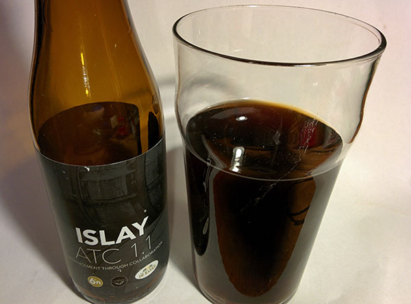
This evening it was time to open the first bottle. Keeping in mind that it is 9.2% alcohol I decided one bottle would have to be enough, even though it is only a 330ml bottle. As a pint glass was all that I had available the presentation is a bit lacking, but at least you get an idea:
I’m no good in tasting and tasting notes, but I must say the description of ‘dark brooding’ hits it for me. That’s really what it seems to be. To me it appeared very smooth, velvety, dark and heavy. But also fruity. Very nice. I’ll certainly enjoy the remaining bottles, money well spent.
I know there are other Islay cask aged real ales out there, certainly something I’ll explore further in the future.
Some music for this Friday evening. Islay related in a number of ways: to start with the song is about whisky. Then it is written and performed by a band who often visits Islay. And large parts of the video were filmed on Islay. I think that’s plenty enough reasons to share it here:
I’ve heard of various ways to get across the North Channel from Islay to Ireland (or vice versa). By plane. By boat (mainly RIB). By Laser sailing dinghy. By kayak. By stand up paddle board. I don’t think I’ve heard of swimming before. That might be about to change:
I don’t know more than is mentioned in the blog post New Swimspiration, The Celtic Quadrant (and the links posted there) I came across today. Of the four swims included in the quadrant one is the following:
The Oa Channel Swim, a 45 km 6-person relay between the Isle of Islay and Ireland in 11°C to 13°C water at £200 per swimmer with a window between 15–20 July 2017 with an estimated time of 18+ hours for crossing.
Mark Gillespie of WhiskyCast is probably mainly known for his whisky related podcasts. However, he also produces videos and I think I probably have shared one or two of his videos before. Recently he published a video about a visit to the Port Ellen Maltings, a place not many get to see, although he kind of picked the wrong day (for reasons explained in the video):
In the video Mark mentions that today only a handful of distilleries do any of their own malting. If memory serves me right there are only about six or seven distilleries left in Scotland who do this, three of them are actually on Islay: Laphroaig, Bowmore and Kilchoman.
 No, I don’t know if their pizza oven will be peat fired. I don’t even know when it will open. All I know is that (hopefully soon) a new pizzeria will open on Islay. In Shore Street in Bowmore to be precise, in the building that most recently housed the Holy Coo restaurant.
 With a cold and wet weekend approaching (at least in West Berkshire where I’m writing this) I thought I should pull together something for you to read. Or in other words, write the follow up to the
  A very interesting concert is coming up on Islay in the second half of March 2017. Organised by
  The music isn’t from Islay and admittedly the artist doesn’t live on Islay any more, but she was raised on Islay and still returns regularly. That’s plenty enough for me. Oh, and paralegal isn’t a musical term, it’s her ‘day job’ where she recently qualified as paralegal.
 A few years ago (well, let’s call it a decade ago) I wrote a post about what I believed to be
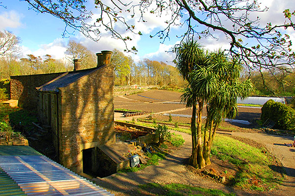
 Yes, it’s the first of the month. No, it’s not April. It’s February. In other words, this is not an April Fools. Some rather interesting news have come out about Islay and whisky legend (or is it whisky and Islay legend?) Jim McEwan in connection with the currently under construction
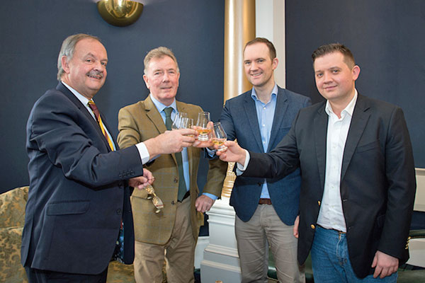
 Something slightly different this evening. Usually the whiskies or beers I mention on this blog are from Islay or at least somewhere in Argyll. This one is from much further afield (from Stonehaven to be precise), but it has been influenced by Islay. Last weekend I stumbled over this tweet:
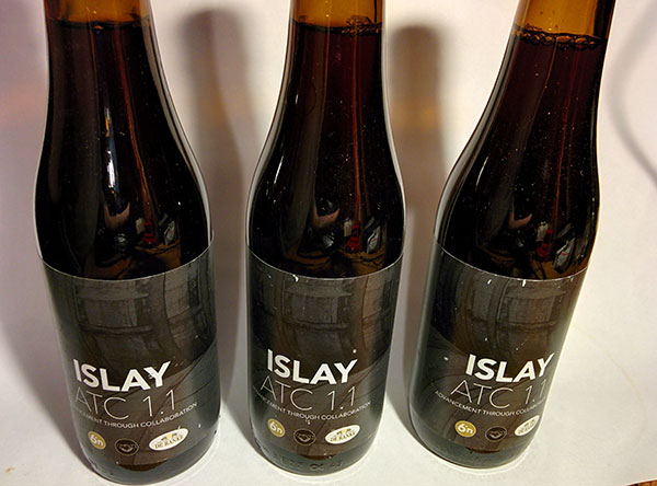
 Mark Gillespie of