Something a bit scary today. I’m not sure how I came across these in the David Ramsey Historical map collection a while ago, but essentially it looks like there was at least some material covering Islay for plans by the German Wehrmacht to invade Britain during WWII (known as Operation Sea Lion, which would have mainly focused on England, but they also seem to have prepared information about Scotland). The material seems to be from 1940 and 1941, i.e. still during the early years of the war. A search for Islay initially turns up three results:
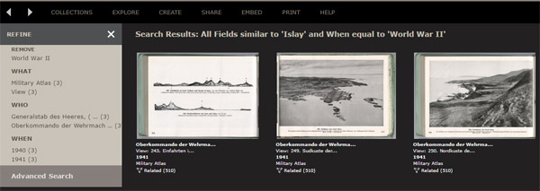
The first one is a drawn coast profile of entrances into Loch Tarbert (on Jura) and the Sound of Islay. The second is called south coast of the Isle of Islay (showing mainly Port Ellen and around). The third one is called north coast of the Isle of Islay and shows the north coast near Rhuvaal.
After a bit of digging around I found a bit more (which for some reason doesn’t show up in a search for Islay):
- River mouth of Allt Bun an Eas (Isle of Jura)
- Drawn coastal profile of the southern entrance of the Sound of Islay (with McArthur’s Head)
- Drawing of McArthur’s Head lighthouse (this I found very interesting as it shows the old lighthouse keeper’s house, which is now long gone)
- The village of Port Ellen (a view from the Ard, very similar to the view today, not that much has changed)
Luckily the plans were abandoned quite quickly but now provide us with some interesting historical pictures.
Some interesting historic documents I hadn’t expected: Preparing for an Islay invasion in WWII? new.islayblog.com/2016/12/27/pre…
tag:twitter.com,2013:813706705678770177_favorited_by_20735614
Rod Graham
https://twitter.com/islayblog/status/813706705678770177#favorited-by-20735614
Fascinating. Why is the lighthouse keeper’s house gone? Demolished (!) or just crumbled away? ?
demolished as no longer needed after automation. Some foundations are still there I think, but that’s about it.
Oh dear (Imagine the holiday rental potential!). I suppose not accessible by road…
not even by quadbike I’d say. Only by sea. And even that might at times be tricky.
Indeed. We couldn’t even find a way over to it on foot from Proaig, ha!
I’ve been a couple of times, but you have to know where you’re going. I certainly is tricky to get there.
One day…
tag:facebook.com,2013:10155137518168268_liked_by_661257183945338
Syl Via
https://www.facebook.com/776938267/posts/10155137518168268#liked-by-661257183945338
tag:facebook.com,2013:10155137518168268_liked_by_806897486034098
Andy Buttery
https://www.facebook.com/776938267/posts/10155137518168268#liked-by-806897486034098
tag:facebook.com,2013:10155137518168268_liked_by_10151957429526901
Enrico Anders
https://www.facebook.com/776938267/posts/10155137518168268#liked-by-10151957429526901
tag:facebook.com,2013:10155137518168268_liked_by_10208432343659718
Anne Kiser
https://www.facebook.com/776938267/posts/10155137518168268#liked-by-10208432343659718
Some interesting historic documents I hadn’t expected: Preparing for an Islay invasion in WWII? new.islayblog.com/2016/12/27/pre…
tag:twitter.com,2013:813706705678770177_favorited_by_3239351872
Benoit Bailey
https://twitter.com/islayblog/status/813706705678770177#favorited-by-3239351872
tag:facebook.com,2013:10155137518168268_liked_by_10203708073289235
Rae Woodrow
https://www.facebook.com/776938267/posts/10155137518168268#liked-by-10203708073289235
tag:facebook.com,2013:10155137518168268_liked_by_737562809598847
Pali Fukatsch
https://www.facebook.com/776938267/posts/10155137518168268#liked-by-737562809598847
tag:facebook.com,2013:10155137518168268_liked_by_1356542174398498
Elizabeth Davis
https://www.facebook.com/776938267/posts/10155137518168268#liked-by-1356542174398498
tag:facebook.com,2013:10155137518168268_liked_by_806032549432284
Seonaid Wilson
https://www.facebook.com/776938267/posts/10155137518168268#liked-by-806032549432284
tag:facebook.com,2013:10155137518168268_liked_by_1581269572135317
Tante Martha
https://www.facebook.com/776938267/posts/10155137518168268#liked-by-1581269572135317
tag:facebook.com,2013:10155137518168268_liked_by_442011952661985
Christina Jamieson Faulks
https://www.facebook.com/776938267/posts/10155137518168268#liked-by-442011952661985
Ooh, freaky! Preparing for an Islay invasion in WWII? new.islayblog.com/2016/12/27/pre… via @islayblog